Visiting the Cloud People’s Past
A few weeks ago, we took a day hike to see the ruins of Kuelep, which is famed to be just as cool as, if not better than, Macchu Picchu…minus the crowds and foreign influence. It may be true. The only buses leave our town at 3am and 5am, so we attempted to take the 5am bus. Somehow that day, there was only a 4am bus and they came to our hostal at 3am to tell us to get ready to leave. What a way to wake up. No one is on time for anything, ever, except the buses usually leave early. After a bumpy couple of hours in the dark, we arrived in Tingo, a small town on the river. From there we could be extremely lucky and catch another bus into Maria to hike a moderate trail a few hours to the ruins. It was dawn and we we groggy and thought just hiking from town would be fine. Sitting around in a tiny town at dawn was not appealing. The guidebook warns that the trail is steep, exposed and hot. It’s 9.8 km of switchbacks (just under 12 miles round-trip). The beginning of the trail followed the river and was pleasant and pretty flat, then it was up up up over around up again. It was intense but I had a new friend to motivate me up the mountain: Wheezy the guide dog. We found out later that this dog in Tingo accompanies most of the tourists up the mountain to the ruins. He was in good spirits the whole time, except for the constant wheezing. I was worried he was going to die on the hike and we’d have to carry him to town and find his owners, but he’s tough.
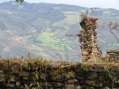
The hike was gorgeous. The valleys were green and beautiful with farms and forests scattered among the steep valley walls. We didn’t see one hiker the entire time up. We walked through a tiny village before reaching the ruins, which was a surprise. Two children from the village followed us for awhile and pointed us in the right direction. We could see the ruins about a half mile away. It is a giant fortress built of rock, dating to 900-1100 ad. It is on the edge of a limestone mountain and the stonework is amazing. The people who built it were called the Chachapoyas, or the Cloud People (because they lived in the cloud forest). They were around and established before the Incas, but were eventually taken over by the Incas, which was shortly followed by the Spanish.
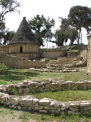
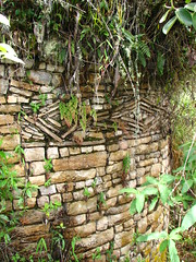
I really enjoy their style of architecture. Round houses! It’s like living in a turret. They weren’t into metal-working like the Chimu or Moche cultures. They were not warriors, either. They were interested in agriculture and stone masonry. All the houses are made of stone and are round, with a pointed tee pee style thatch roof. Kuelep was “discovered” in 1843, but overgrown with trees and vines and bromeliads. Their ruins are found on high points on mountains and hills. Some people say it has more stones than the great pyramid of Egypt and I believe it. They were into details too, and a lot of houses have designs around the base (zig zags, rhomboids). The ruins were crazy; obviously no roofing remained but all the round stone foundations are visible and most have trees growing in the houses. Only a small portion of it is reconstructed or exposed, but it was plenty to see and I preferred to see the ruins with this jungle of a forest taking over it. They were the most beautiful ruins I had seen so far: mountain top stone houses with a view. Most houses have a sort of root cellar/hole dug into them and archaeologists believe some of it was for food storage but most of it was for burying their ancestors. Yep, the grandparents were buried in the “basement.” A few grinding stones (for making pesto, of course) were also in the houses. A really interesting thing about the fortress wall is that it only has 3 entrances and the complex is 3 times the size of a football field. Each entrance is designed in such a way to taper down and become narrower so that by the time you are close to the complex you have to enter single file. I think this was a protection against attack. It’s beautiful there, did I mention that? But eventually we had to make the return hike to town (a slow 4 hours up, about a moderate 3-3.5 hours down) to try to catch the last bus home again…which we saw leaving Tingo while we were on the river trail. We were exhausted but had considered staying in town to do another hike the next day…but after that elevation and steep hike, I just wanted to relax. We were both disappointed and after asking a handful of locals if that really was the last bus (they said yes) and trying to get a shared taxi (none) we just sat in town with Wheezy and drank the last of our water. A cop or town something arrived in town and I thought I’d ask him if there were ANY other buses coming and he said probably in 15 minutes and I heard the locals laughing and telling him the last bus came. Luckily for us, in 15 minutes another bus came in our direction and we were able to go home, shower and relax.
The following week we took a day hike to La Congona, another Chachapoyas site. This one is hikeable from Leymebamba and we were invited to go with one of our adult students (who, ironically is also an English teacher at the local school) and two of his students. The hike to La Congona follows a series of steep rocky switchbacks which reminded Matt more of logging roads than a hike through the farms. We learned that the area used to be all forest, but they logged it all to build houses (and didn’t replant) then turned the open space into pasture or farmland. It at least explains the landscape a bit better. The farms around here are so steep and up these mountains. I wouldn’t consider planting my potatoes let alone till the land, but everyone does it and most people’s farms are on average a 3 hour hike from town.
Anyways, the hike to La Congona was steep and muddy and we were going against traffic. Everyone from the mountains was heading to Leymebamba for the market, carrying babies and firewood and eggs and drop spindling as they navigated their way down the mountain in galoshes. I was having a hard enough time getting proper footing…I can’t imagine spinning yarn in that sort of footwear. Sometimes I feel like such a wimp compared to these mountain women, carrying loads on their backs, spinning yarn and their 5 year old daughters are carrying the babies. The hike was beautiful, as expected. Rolling mountains of farms and trees, cows and horses grazing, occasional chickens making their ruckus. I really like the mountains here (except that steep uphill!)
The ruins at La Congona are smaller than Kuelep, but still quite beautiful. They are on a hilltop on some farmer’s property. It’s a much narrower ridgeline than Kuelep but there’s a bunch of round stone foundations standing, some 10-15 feet high, with intact niches in the walls (for offerings? candles? somewhere to put your coffee cup?) and there’s two round buildings very close together with a stone staircase to head up to the top. I guess that’s the tower because the view is practically a 360 degree view (minus all that new vegetation) We were the only tourists there, it’s not developed at all or reconstructed and I liked the feeling of being in this lost, abandoned world. The houses here also had the decorative slate friezes and one house had a square foundation for the round house, which is very strange but shows the Inca’s presence (they build houses with corners). We enjoyed a lazy lunch and learned a lot of folklore about the town, complete with witch doctors and shamans creating trouble. Our hike back down was a little tougher as we got caught in the middle of a huge rainstorm and had to run to a farmhouse to wait it out as best as we could. The hike down was muddy, slippery and fun.
October 28th, 2008 at 1:40 pm
Good post.